The Fish River Canyon Part 1
Created | Updated Jun 20, 2003

Hiking in Namibia
The Fish River Canyon in Namibia is Africa's longest canyon, and second in the world only to the Grand Canyon. Besides being an important conservation area, the canyon is home to a 90km hiking trail which attracts the young, the old, the fit and the not so fit. In fact the only thing all the hikers have in common is a desire to get from Hobas in the north to Ai-Ais in the south. They don't even all want to do it as fast as possible... some people return year after year for their mid-winter break and will take up to 8 days to hike the trail. They are balanced however by a few people who try to get through the canyon as fast as possible; there has been a spectacularly unsuccessful attempt to ride a motorbike down the canyon, while 3 men once ran from start to finish in one morning. Some friends of ours had hiked the canyon about 6 years ago, and still say it's the best holiday they ever had, so my parents decided that they would come and meet my friend Sarah and I in Namibia (we had been in Zimbabwe and Botswana) and that we would hike the trail.
The trip was necessarily planned a long time in advance. The hiking trail is only open for three months of the Namibian winter, and less than 40 hikers a day are allowed in, so you have to reserve a place up to 18 months in advance and then this will be confirmed about a year before you want to hike. The details you get sent, however, are decidedly hazy, and you can end up not entirely sure what you're in for. When we arrived at Hobas the night before we were due to start hiking we were presented with a sketch map of the trail, and managed to arrange (with the help of Mum's 25-years of neglected Afrikaans) to have the car driven down to Ai-Ais to meet us.
Apparently it is possible to get a proper map of the Fish River Canyon and a leaflet telling you need-to-know facts, however there were none at Hobas (we did manage to get one at Ai-Ais when we finished). The average time for hiking the trail is 5 days (3 if you start from the 'escape route' above Palm Springs) and this is what we were aiming for, although because we were planning on camping at Ai-Ais when we finished we could easily allow ourselves a sixth day.

The night before we started the trail we camped at Hobas and sorted out all our equipment. We each carried a small mosquito net tent, sleeping bag and cutlery, plus various other neccessities such as spare clothes, torches and books. Between us we also carried a small methylated spirits stove, and a small pellet fuelled stove, and large quantities of food... primarily rice, pasta, biscuits and fruit. It doesn't sound like too much stuff, but it seemed to fill the vast majority of four rucksacks, and led to a rush every meal time as we all tried to offload some of the weight we were carrying.
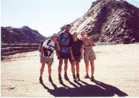
We had arranged to be given a lift to the trailhead at 7am on the first morning of our hike, rather than walk an extra 10km. One result of this was that we hardly got a glimpse of the canyon before we hiked it, and so we still had very little idea of what we were letting ourselves in for. In retrospect this was probably quite a good thing as, if we'd seen the length and twists of the canyon, we might have thought very hard before posing for the obligatory pre-hike photo and plunging into the canyon.
Day One
Actually we didn't plunge. Not even slightly. We walked forward 10 paces and then looked down. The route down was extremely steep, with only rare, small, fragile steps breaking up the path of small, loose rocks, and with only the occasional bit of chain to hang onto as you manoeuvred yourself around a bend in the path. It was at this point that we set the order of walking that would last for the duration of the hike; Dad and Sarah boldly went on ahead to explore the upcoming terrain, while Mum and I bravely brought up the rear, acting as official photographers (i.e. our legs weren't as long as theirs).
Having left the top of the canyon at 7:30 we arrived at the river about 4 hours later, having been passed by some day hikers who were basically going down to the river and back up again in the shortest possible time. When we reached the river... a beautiful greenish colour, but perfectly safe to drink... we promptly stopped for lunch. We thought we deserved it, apart from anything else our rucksacks needed lightening, also we quite fancied a swim in the river. Once we had felt the water we decided that actually we just fancied a very quick dip to cool off.
When we started walking again an hour and a half later, we discovered that we really should have kept going for as long as possible before lunch. We were then walking across long stretches of sand interspersed with large boulders to scramble over, and the occasional stretch of flat rock in the heat of the day. Mum was so exhausted in half an hour that we had to stop and rest, and my plaintive cry was;
'I'm not a camel, why are you making me do this?'.
It was probably fortunate that none of us knew that we would be walking on the same kind of ground for most of the next 6 days!

We struggled onwards for a while and found a nice place to camp at about half past four. Then we looked at the map. It was then that we realised how astoundingly useless the little sketch map was. We may not have needed map-reading skills in the strictest sense of the phrase since we simply had to follow the river, but it was neccessary that we could tell where we were and what kind of speed we were hiking at so we could be prepared for our food to run out before we reached Ai-Ais. We were fairly lucky to have a tiny scale map of the Fish river Canyon on the map of the Namibia road map Dad carried, but even so it became common for the map to laid out and the question asked;
'Where do we think we are?'
At this point, four fingers would land on the map in four different places. We discovered later that we had only walked 4.5km on the first day. In spite of this we were actually fortunate in stopping when we did. We discovered the next day that there were few other places to camp within 2 hours walk, and it got dark every night between 5:30 and 6pm. Also we were camped against the side of the canyon and so absorbed the warmth of the nearby rocks.
